
| Sportime 022258 GEOSPOTS SET/50 107321 |
| GeoSpots is the perfect brain compatible physical education tool that can turn a geography lesson into a moving experience! Each set includes 50 of Sportime s 10-diameter (25.4cm) Utility/Sequencing Spot Markers with each spot dedicated to the identification of a single state. In addition to their use in lessons of geography Utility/Sequencing Spots Markers are perfectly sized for countless non-cognitive activities. They can be stepped upon run over rolled or putted to and tossed at. While ideal for outdoor use their Super Non-Slip Formula keeps them where they re put on virtually any smooth indoor surface too. The variable designs on these two-sided spot markers can be used to adjust the program s level of difficulty. One side of each GeoSpot disk challenges students to identify a particular state based upon its outline 2-letter postal abbreviation capital s name and location (indicated with a Capital Star). The other side of each disk presents a more difficult challenge by displaying only the state s outline and capital star location. To understand the difficulty of this challenge visualize the states of Colorado and Wyoming. Because both state outlines are virtually identical only knowing that Wyoming s capital Cheyenne is located in the lower right-hand-corner would help differentiate these two states. You can add yet another layer of difficulty with a GeoScramble. In a GeoScramble states are positioned randomly either on a regional or universal basis. If you thought identifying the outline of Georgia was difficult try recognizing it out of position. While we do not want to redefine the rules of cartography we maximize the state s size on each 10 GeoSpot and proportionalize the capital s star to define the representative state size. For example states like Maryland become nearly invisible in an environment where it must be in the exact proportion to California. In fact even Alaska must be shown as only a fraction of i
Price: 195.10 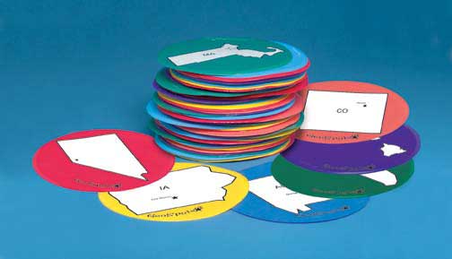 |